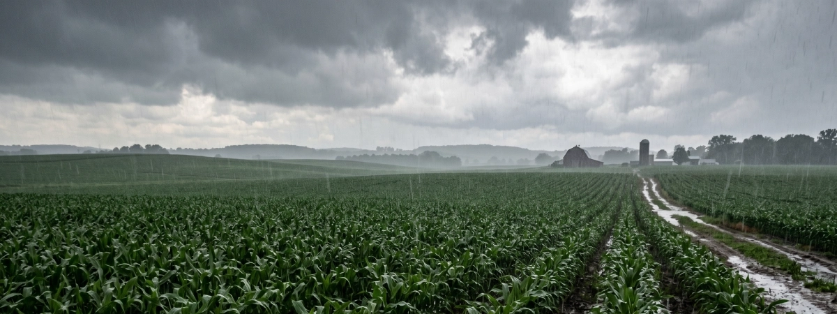
After a brutally dry April across most of the south-east, the cold fronts that moved through in the first two weeks of May brought some welcome – if uneven – relief. Most cropping regions in Victoria, South Australia and New South Wales recorded falls between 10 and 50 millimetres. For some growers it was enough to get on the tractor. For others, it just wasn’t. Understanding what those falls actually mean for the soil profile, and what the outlook says about the weeks ahead, should be driving your decisions right now.
The week ending 6 May saw cold fronts push across much of the south-east. Victoria’s Wimmera and western districts were among the better-served areas, with many locations recording 15-50mm. Parts of central and southern NSW also received useful falls, Condobolin and West Wyalong saw around 60mm, Temora 62mm, Young 65mm. SA’s cropping regions received similar totals across much of the Eyre Peninsula and the mid-north.
The second week of May was lighter. Most of Victoria and SA recorded modest top-ups of 5–15mm, while NSW and Queensland saw little to nothing. Northern NSW and south-eastern Queensland, which had already been running on fumes, stayed largely dry through both events.
The practical upshot: growers from the southern Wimmera down through the south-east of SA got a genuine opening. Many were on the tractor within days. Across central and southern NSW, the response was more cautious, useful falls, but coming off a very low base after NSW recorded its second driest April on record since 1900.
Rain on a rain gauge and moisture in a soil profile are two different things, and right now the gap between them matters enormously.
Across Victoria and SA, topsoil moisture has recovered well enough in many paddocks to support germination. The question is what sits underneath. After a dry summer and a near-absent autumn, subsoil reserves in many parts of the Mallee, the Eyre Peninsula and the western districts are well below average. A 20–30mm event wets the top 5–8cm but doesn’t reach the 30–60cm zone that carries a crop through September and October.
In northern NSW and southern Queensland the picture is worse. Soil moisture deficits have been building for months. The falls in early May were welcome but, as ABARES noted, likely insufficient to encourage widespread winter crop planting in those areas. Growers further north should be doing a probe test before committing to a full program, the topsoil may look moist while the subsoil is still very short.
For the southern cropping zones, the recent falls have provided enough for canola establishment and cereals sown at the right depth. Whether that subsoil recharges during June and July is the critical question.
Here is the part that deserves serious attention.
The Bureau of Meteorology’s long-range forecast for June to August gives a 60–80% probability of below-average rainfall for most of Victoria, southern and eastern SA, inland NSW, and south-eastern Queensland. The South West Land Division of WA is in the same camp. Above-average temperatures are very likely across almost all of southern Australia during the same period.
ENSO is currently neutral, but models are pointing toward El Niño development during winter. That transition, if it confirms, typically tightens the rainfall screws further across southern cropping regions in the second half of the season, exactly when crops are filling grain.
What this means practically: the May falls have given the south a chance, but they haven’t changed the season. They have shifted you from a very difficult position to a difficult one. Your crop will likely need to run on whatever moisture is in the profile from establishment onward, with limited in-crop rainfall to lean on.
This is not a reason to stay on the header. It is a reason to make every decision from here, variety, depth, row spacing, fertiliser rate, around water use efficiency rather than yield potential.
These areas are in the best shape in the south-east right now. The May falls hit well-structured country with some residual subsoil moisture from last year’s later-season rains. Canola planting is underway and conditions are broadly suitable for cereals. The risk here is over-confidence, the June–August outlook still favours below median, and crops establishing now will need to go a long way on what’s in the ground. Keep input rates commensurate with realistic yield expectations, not optimistic ones. A soil test before you top-dress is worth every cent when you’re running lean.
Topsoil moisture is adequate in spots, poor in others. Subsoil moisture is the concern, summer was very dry and the autumn was worse. Canola is high risk on lighter country. Cereals are more forgiving, particularly varieties with good early vigour and deeper coleoptile length that can seek moisture below a dry surface layer. If you’re dry sowing here, consider dropping seeding depth toward the lower end of the range rather than chasing moisture too deep on country where topsoil is warm but not wet.
The recent falls were meaningful for some districts, marginal for others. Temora–Young–Condobolin received some of the better totals, and early reports suggest planting has started on stronger soils. For the lighter country, the subsoil situation warrants caution. A pulse crop on thin soils with marginal topsoil moisture and a poor June–August outlook is a risk most seasons. This one more so.
This is the area of greatest concern nationally. Soil moisture deficits have been entrenching for months. The early May falls provided a temporary boost at the surface but subsoil moisture in most of these cropping regions remains severely deficient. ABARES has flagged a significant decline in winter crop area planted for 2026–27 in these regions as a direct result. If you’re in this zone, the decision isn’t just what to plant it’s whether to plant winter crops at all, or to direct that capital toward fodder crops, pasture renovation, or simply preserving cash until the season breaks properly.
The window between now and mid-June is where most of the south-east’s crop area will be committed. A few things worth having clear before you hook up the seeder:
Probe your soil before you plant. Topsoil moisture is visible. Subsoil moisture is not. A soil probe to 60cm takes ten minutes and tells you whether you have a crop season or a risk season. Pay particular attention to the 30–60cm zone.
Reassess your canola allocation. Canola is the most moisture-hungry crop at establishment. On country with marginal subsoil, shift area toward cereals or a drought-tolerant pulse. The yield upside of canola doesn’t justify the downside risk if June and July stay dry.
Match variety to conditions, not to price lists. For cereals going into marginal moisture, prioritise varieties with proven performance in low-rainfall seasons and good early vigour. Scepter remains a reliable option in NSW and WA; Rockstar and Vixen have shown strong performance in tight seasons across Victoria. Check your state’s current NVT data before finalising.
Revisit your fertiliser plan. In a year where in-crop rainfall is likely to be below average, you will be chasing a lower yield ceiling than in a wet year. Applying nitrogen against an optimistic yield target on a profile that may not recharge is a cost you won’t recover. Get a soil test done it takes the guesswork out and in many cases will tell you to apply less, not more.
Watch for the next significant rain event closely. The recent falls have opened a window, but the JJA outlook suggests that window could close before it fully charges the profile. If a system is tracking for 25mm or more in late May or early June, that may be the last genuinely useful precipitation before crops need to carry themselves. Time your final sowing push around that event if you can.
The 2025–26 season produced a strong national crop despite a dry start dry sowing worked, late rains delivered, and yields surprised on the upside in several states. Growers are rightly asking whether the same pattern might repeat in 2026–27.
It might. But the lead-in conditions are materially worse. Subsoil moisture reserves going into this winter are lower than they were a year ago. The rainfall outlook for June–August is more pessimistic. And the probability of an El Niño establishing during winter which would further reduce in-crop rainfall is significant.
The recent May falls are genuinely good news. They have given the southern cropping belt a working start. The appropriate response is to use that start carefully plant the right crops, at the right depth, with input rates calibrated to a realistic yield, and make sure you know what’s actually in your soil profile before you commit.
For feed and hay testing to support livestock feed planning this season,Feed Central offers independent analysis across hay, silage and grain useful when you’re substituting away from lucerne or managing supplementary feeding in a tight season.
Sources: ABARES Weekly Australian Climate, Water and Agricultural Update (7 May 2026, 14 May 2026); Bureau of Meteorology Long-Range Forecast June–August 2026; BoM April 2026 Drought Statement.
Search our marketplace